


Breaking News
 Rising Prices and Falling Values--Inflation and Social Decay
 The non-Zionist Israeli Population Could Save the Day
 AfD Launches 'Knife App' As Berlin Violence Surges
 Oil Prices EXPLODE After Trump Signals That US Is Moving To Wartime Economy
Top Tech News
 DARPA O-Circuit program wants drones that can smell danger...
 Practical Smell-O-Vision could soon be coming to a VR headset near you
 ICYMI - RAI introduces its new prototype "Roadrunner," a 33 lb bipedal wheeled robot.
 Pulsar Fusion Ignites Plasma in Nuclear Rocket Test
 Details of the NASA Moonbase Plans Include a Fifteen Ton Lunar Rover
 THIS is the Biggest Thing Since CGI
 BACK TO THE MOON: Crewed Lunar Mission Artemis II Confirmed for Wednesday...
 The Secret Spy Tech Inside Every Credit Card
 Red light therapy boosts retinal health in early macular degeneration
 Hydrogen-powered business jet edges closer to certification


2 Feet Of Now In At Least 5 States And Hurricane-Force Winds: The Northeast Has Just Been...
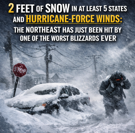
The blizzard that hit the Northeast on Monday looked like it could have been pulled directly out of a Hollywood disaster movie. Everyone knew that it was going to be bad, but it turned out to be significantly worse than most of the experts were projecting. Multiple states have recorded more than 2 feet of snow. Multiple states have recorded hurricane-force winds. I have frequently written about how global weather patterns have been going completely nuts, and this is yet another example. The Northeast has just been hit by one of the worst blizzards in history, and the snow is still falling in many areas.
The reason why this storm turned out to be so powerful is because it intensified extremely fast just before it struck. The central pressure of the storm fell by 40 millibars in just 24 hours, and Accuweather is telling us that this represents "a dramatic drop that is even rare for powerful hurricanes"…
A bomb cyclone is a storm that strengthens extremely fast, and this nor'easter did exactly that along the Northeast coast from Sunday into Monday. The air pressure at the center of the storm plunged as it intensified. A storm earns "bomb cyclone" status when its central pressure drops at least 24 millibars (0.71 of an inch of mercury) in 24 hours. The nor'easter reached this benchmark in just 18 hours, with the pressure hitting the bomb cyclone threshold at 1 a.m. EST Monday — and it didn't start there.
Over a 24-hour stretch, the pressure fell 40 millibars (1.18 inches of mercury), a dramatic drop that is even rare for powerful hurricanes.
From space, this blizzard closely resembled a hurricane to many people.
But it wasn't a hurricane.
It was considered to be a "bomb cyclone", and CNN is reporting that at least 2 feet of snow has fallen in at least five states…
• Whiteout conditions ongoing: A high-impact bomb cyclone is slamming the Northeast with powerful winds and extreme snowfall rates, knocking out power and making travel impossible. Thirty million people are under blizzard warnings.
• Snow piling up: More than 30 inches of snow has fallen so far, with 2 feet reported in at least five states. It's the biggest snowstorm on record for Providence, Rhode Island, and in years for New York City and Philadelphia … and snow is still falling.
• Northeast shut down: Treacherous conditions paused public transit, forced travel bans and prompted warnings to stay off roads. More than 10,000 flights have been canceled, according to FlightAware.
Snow was falling at a rate of at least two inches an hour in much of the region.
That would be bad enough.
What made conditions far worse were the howling, hurricane-force winds which never seemed to stop…
Winds gusted to 83 mph at Nantucket, with 77 mph at Wellfleet, Massachusetts. Gusts to 74 mph were recorded at Gosnold, Massachusetts , and Kingstown, Rhode Island. As of noon, 657,000 customers were without power after the high winds, with 284,000 of those in Massachusetts, according to PowerOutage.US.