


Breaking News
 'Its The Economy, Stupid!' Black And Hispanic Voters Embrace Trump On Economics And Well-Bei
 We Need To Do With the State What We'Ve Done With Slavery
 Is the 'Housing Shortage' the Result of Housing-Hoarding by the Wealthy?
 The Dark Origins of the Davos' Great Reset
Top Tech News
 Blazing bits transmitted 4.5 million times faster than broadband
 Rewiring
 Scientists Close To Controlling All Genetic Material On Earth
 Doodle to reality: World's 1st nuclear fusion-powered electric propulsion drive
 Phase-change concrete melts snow and ice without salt or shovels
 You Won't Want To Miss THIS During The Total Solar Eclipse (3D Eclipse Timeline And Viewing Tips
 China Room Temperature Superconductor Researcher Had Experiments to Refute Critics
 5 video games we wanna smell, now that it's kinda possible with GameScent
 Unpowered cargo gliders on tow ropes promise 65% cheaper air freight
 Wyoming A Finalist For Factory To Build Portable Micro-Nuclear Plants


Ridgecrest earthquakes caused damage to Earth's crust seen from satellite
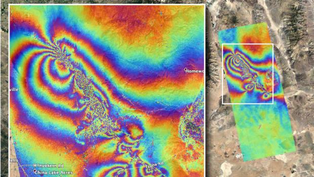
The Advanced Rapid Imaging and Analysis team at NASA's Jet Propulsion Laboratory in Pasadena used satellite data to produce a map showing ruptures and displacements not visible to the naked eye — employing technology that has been developed over the last quarter of a century. The imagery was acquired on July 8 and compared with data from April 8.
The earthquakes were the largest to hit California in nearly 20 years and were felt as far away as Phoenix and Mexicali, Mexico. The temblors and the thousands of aftershocks that followed did not lead to major structural damage near the Ridgecrest epicenter but did have residents of nearby Trona, Calif. worrying about their town's future.
Authorities were investigating whether the death of a man 95 miles away in Pahrump, Nev., was tied to the earthquake. The man was pinned under a Jeep after the vehicle fell off its jacks.