


Breaking News
 Elon Musk The Economist July 23rd 2026 - FULL Interview
 Meltdown? The Real Reason Why The Media Hates Elon Musk
 Bitcoin Debate: Pomp DESTROYS Peter Schiff
 Oil shipments are under attack on multiple fronts as fighting escalates in Red Sea, Hormuz...
Top Tech News
 Elon Vows AI-Made 'Odyssey' After Blasting Nolan's Take On Homer
 Anthropic is launching its own drug discovery programs for rare diseases using Claude...
 SpaceX AI Satellites Will Have 250 Kilowatts of Power
 Chinese researchers have developed a sodium-metal battery that can fully charge in just 4 minutes...
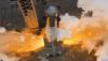 SpaceX Starship Flight 13 in 3 Days - Thursday July 13
 Chinese Scientists Develop Nuclear Battery Using Carbon-14
 Teleoperated humanoid robots complete first-ever live surgery
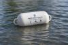 Floating capsule auto-disinfects water without chemicals or battery
 Modular Reactors To Solve Data Center Hysteria?
 DeepSeek Developing In-House AI Chip In Bid To Cut Nvidia Reliance


NOAA's Tiny Boat Drones Map The Ocean's Shallow Floors
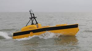
What shore knows not our maps? Most of them, it turns out. While satellites map much of the globe on a daily basis, there are parts of the planet so small and changing that they're tricky to pin down exactly. NOAA, America's National Oceanic and Atmospheric Administration, makes maps that anyone who navigates the sea can use, and to get the fine details on little inlets right, they turn to…
"Autonomous Surface Vehicles," also known as sea drones and (at least at Popular Science) as Roboats. While much of NOAA's sea plotting is done by ships, the smaller robots can swim to shallow inlets and areas, capturing parts of the ocean otherwise unknown. Using sonar and other measures, they plot the topography of the ocean floor, including details like sandbar shifts. Or, in other words, with sound they sound out the details of sounds.