


Breaking News
 BREAKING NEWS: DOJ Indicts Far-Left Southern Poverty Law Center on 11 Counts
 Trump Gives an Indefinite Cease-Fire to Iran. What Is This War?
 BREAKING: President Trump Extends Ceasefire with Iran at Pakistan's request
 A well site explosion triggers a large fire and evacuations in Texas, but no injuries
Top Tech News
 Researchers Turn Car Battery Acid and Plastic Waste into Clean Hydrogen and New Plastic
 'Spin-flip' system pushes solar cell energy conversion efficiency past 100%
 A Startup Has Been Quietly Pitching Cloned Human Bodies to Transfer Your Brain Into
 DEYE 215kWh LiFePO4 + 125,000W Inverter + 200,000W MPPT = Run A Factory Offgrid!!
 China's Unitree Unveils Robot With "Human-Like Physique" That Can Outrun Most People
 This $200 Black Shaft Air Conditions Your Home For Free Forever -- Why Is It Banned in the U.S.?
 Engineers have developed a material capable of self-repairing more than 1,000 times,...
 They bypassed the eye entirely.
 The Most Dangerous Race on Earth Isn't Nuclear - It's Quantum.
 This Plasma Stove Cooks Hotter Than The Sun


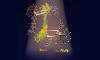
This animated globe showing animal migration routes is mesmerizing
Animals have don't need passports or visas, and they don't care about countries' borders — and that's vividly illustrated by this animated globe.
It shows migration routes for about 150 species based on tracking data shared by over 11,000 researchers from around the world. The pink lines follow the movement of animals covering at least 310 miles in one direction for at least 45 days, combining about 8,000 tracks collected over a period of about 10 years. You can see lines extend from Africa to Turkey, all the way up to Europe, as well as from Canada to the United States, and vice versa.
Tracking devices have been used by scientists for a long time to study how animals move within local regions and migrate across oceans and continents. In the past, scientists used to tie bands around birds' legs or use radio transmitters. Today, trackers and tags use GPS and satellites to record data down to the second. The information can help us understand how animals hunt, how they are responding to climate change, or habitat fragmentation — or even just why baby sharks hang out at LA beaches.