


Breaking News
 Brace yourself for a SUPER El Niño: Likelihood of unusual climate pattern skyrockets...
 Researchers reconstruct 42 missing pages from a major early Christian manuscript...
 Russian scientists 'are developing the world's first drug to delay ageing' months after
 Woke hypocrites rage at NYC's socialist mayor for moving homeless into famously liberal...
Top Tech News
 Researchers Turn Car Battery Acid and Plastic Waste into Clean Hydrogen and New Plastic
 'Spin-flip' system pushes solar cell energy conversion efficiency past 100%
 A Startup Has Been Quietly Pitching Cloned Human Bodies to Transfer Your Brain Into
 DEYE 215kWh LiFePO4 + 125,000W Inverter + 200,000W MPPT = Run A Factory Offgrid!!
 China's Unitree Unveils Robot With "Human-Like Physique" That Can Outrun Most People
 This $200 Black Shaft Air Conditions Your Home For Free Forever -- Why Is It Banned in the U.S.?
 Engineers have developed a material capable of self-repairing more than 1,000 times,...
 They bypassed the eye entirely.
 The Most Dangerous Race on Earth Isn't Nuclear - It's Quantum.
 This Plasma Stove Cooks Hotter Than The Sun


Brace yourself for a SUPER El Niño: Likelihood of unusual climate pattern skyrockets...
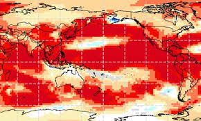
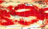
Scientists have warned that the world could be on track for a so-called 'super El Niño', which could push global temperatures to record highs.
El Niño years form part of a natural cycle known as the El Niño-Southern Oscillation, and are marked by sustained warm temperatures across the Pacific Ocean.
Where this ocean surface warming exceeds 2C (3.6F), the event is often referred to as a 'super El Niño', although scientists themselves don't use the term.
Now, the World Meteorological Organisation (WMO) warns that the return of strong or super El Niño conditions is likely as early as May or June.
Current measurements show that sea surface temperatures in the tropical Pacific are rising faster than at any other time this century.
While it is not yet certain, this is a very strong sign that a powerful El Niño weather pattern is brewing.
Wilfran Moufouma Okia, Chief of Climate Prediction at WMO, says: 'Climate models are now strongly aligned, and there is high confidence in the onset of El Niño, followed by further intensification in the months that follow.
'Models indicate that this may be a strong event.'
The El Niño-Southern Oscillation is a natural climate pattern which cycles between a hot El Niño and a cool La Niña phase every two to seven years.
During the El Niño part of the cycle, warm waters that build up in the Pacific spread out and raise the Earth's average surface temperature.
This heat ends up escaping into the atmosphere, raising the planet's temperature for months.
Although this cycle has been going on for hundreds of thousands of years, current signs in the Pacific point to this year being one of the strongest El Niño patterns ever recorded.
It can be hard to predict events beyond April due to the natural changes of the seasons – known as the spring predictability barrier – but experts are almost certain that a strong El Niño is on the way.
A spokesman for the Met Office told the Daily Mail: 'Current forecasts indicate a strong shift in the tropical Pacific later this year, with conditions increasingly supportive of the development of El Niño.'
The Met Office's modelling suggests that sea surface temperatures could reach 1.5C (2.7F) above average, adding that this could be the 'strongest El Niño event so far this century'.
Meanwhile, the American National Oceanic and Atmospheric Administration (NOAA) predicts there is a one in four chance of a 'very strong' El Niño, with temperature anomalies over 2C (3.6F).