


Breaking News
 Super El Niño is on its way: Scientists warn there's now an 80% chance the unusual climate...
 Trump reveals his pick to replace embattled Tulsi Gabbard as intel chief
 Warren Buffett's heir at Berkshire Hathaway spends a cool $17 billion on two megadeals...
 Bringing Sexy Back: Victoria's Secret Shoots Higher After Abandoning Woke Ideology
Top Tech News
 Elon and SpaceX Have Made AI Training 10 Times Faster
 Oklo COO Says Nuclear Waste Could Power America For 150 Years
 SpaceX Announces LARGEST Starship Mission Ever! They've never done this before!
 Cars Are Fast Becoming Dystopian Prison Pods...
 Our Emergency Water Plan Wasn't Good Enough - So We Built This
 Sodium Ion Batteries Can Reach 100 Gigawatt Per Hour Per Year Scale in 2027
 Juiced Bikes proves capable electric motorcycles don't have to cost a lot
 Headlight projectors turn your car into a drive-in theater
 US To Develop Small Modular Nuclear Reactors For Commercial Shipping
 New York Mandates Kill Switch and Surveillance Software in Your 3D Printer ...


Super El Niño is on its way: Scientists warn there's now an 80% chance the unusual climate...
A Super El Niño is on its way, and is almost certain to arrive this summer.
That's according to scientists from the World Meteorological Organisation (WMO), who warn there's now an 80 per cent likelihood of an El Niño event during June–August 2026, and a 90 per cent chance this will continue until at least November.
Worryingly, the experts predict the rare climate event will bring extreme heat 'nearly everywhere' - including the UK and US.
So, what does this mean for us?
While each El Niño varies, the event typically brings increased rainfall in parts of southern South America, the southern United States, parts of the Horn of Africa and central Asia.
In contrast, there will be drier conditions over Central America, northern South America, the Caribbean, Australia, Indonesia, and parts of southern Asia.
Meanwhile, scientists say there's a strong chance 2026 will be the hottest year ever recorded.
That could mean beating the record set in 2024, when global warming exceeded 1.5°C (2.7°F) above the pre–industrial average for the first time.
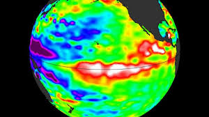
The El Niño–Southern Oscillation is a natural climate pattern which cycles between a hot El Niño and a cool La Niña phase every two to seven years.
During the El Niño part of the cycle, warm waters that build up in the Pacific spread out and raise the Earth's average surface temperature.
This heat ends up escaping into the atmosphere, raising our planet's temperature for months.
This cycle has been going on for hundreds of thousands of years.
However, current signs point to this year being one of the strongest El Niño patterns ever recorded.
From late April to mid–May, the sea–surface temperature in the central–eastern Equatorial Pacific – the area used as a monitoring reference – was approaching El Niño thresholds, according to the WMO.
These increasing surface temperatures are being fed by unusually warm subsurface water in the tropical Pacific.
Temperatures down there are a whopping 6°C above average – providing a 'substantial resevoir' of heat, the WMO explains.