


Breaking News
What's the Point of Rocketing to the Moon and Mars?
 Apple FORCES iPhone Users To Prove Age With ID Or Lose Unrestricted Internet Access
 Iran War Silver Lining: NATO's Death Knell?
 US Retail Sales Jumped Most In 8 Months In February
Top Tech News
 DARPA O-Circuit program wants drones that can smell danger...
 Practical Smell-O-Vision could soon be coming to a VR headset near you
 ICYMI - RAI introduces its new prototype "Roadrunner," a 33 lb bipedal wheeled robot.
 Pulsar Fusion Ignites Plasma in Nuclear Rocket Test
 Details of the NASA Moonbase Plans Include a Fifteen Ton Lunar Rover
 THIS is the Biggest Thing Since CGI
 BACK TO THE MOON: Crewed Lunar Mission Artemis II Confirmed for Wednesday...
 The Secret Spy Tech Inside Every Credit Card
 Red light therapy boosts retinal health in early macular degeneration
 Hydrogen-powered business jet edges closer to certification


"Mother Nature Stops For No One": All Eyes On Next Winter Storm Threat For US East
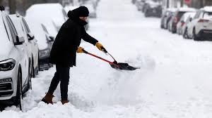
A day or so after the historic winter blast buried much of the eastern half of the US in snow and ice and unleashed dangerously cold air that strained power grids from ERCOT to PJM, forecasters are now tracking another winter threat with potential impact on the Southeast, Mid-Atlantic, and Northeast later this weekend.
Meteorologist Ben Knoll published a note earlier today that warned of "high confidence that a powerful storm, packing blizzard conditions, will form near the East Coast. How close or far that storm is from the coast is less certain."
On X, Knoll wrote:
Another day, another weather update! The last week has been among the busiest I've had in my career so far.
Mother Nature stops for no one, so the forecasts must keep flowing. Compared to yesterday, there's a little more clarity in the weekend forecast, but it isn't set in stone.
Will this weekend's powerful storm be closer to the coast or farther offshore? That's the key question. For now, the highest chances for impacts are along the coast from North Carolina's Outer Banks to southeast New England.
He noted:
This storm's strongest snow signals are located in the Carolinas, coastal Mid-Atlantic and coastal New England. Of course, there's a chance things trend back west, so keep watching!
Frigid across much of the Lower 48 with 260 Million + below freezing and 90% by area
— Ryan Maue (@RyanMaue) January 27, 2026
Some moderation across Texas and the South this afternoon, including Nashville 33°F to 35°F in early afternoon pic.twitter.com/kVIJMb52rR
Will this weekend's powerful storm be closer to the coast or farther offshore?
— Ben Noll (@BenNollWeather) January 27, 2026
That's the key question.
For now, the highest chances for impacts are along the coast from North Carolina's Outer Banks to southeast New England. pic.twitter.com/HYsXLyJhhL